

Earth Observation (EO) satellites provide critical data for science, policy, and industry. A key parameter that determines the value of this data is resolution, which defines the level of detail a sensor can capture.
The Four Core Types of Resolution
1. Spatial Resolution
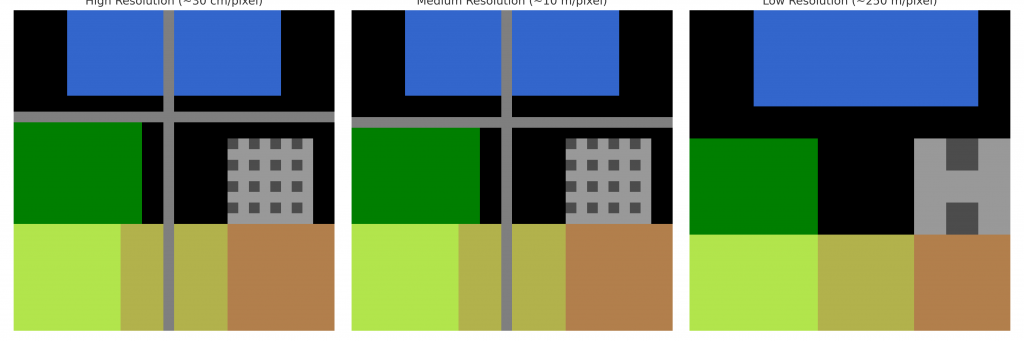
Spatial resolution indicates the size of the smallest ground object that can be distinguished. For example, a 1 m spatial resolution sensor produces pixels that each represent 1 × 1 m of ground. This allows features such as vehicles or small buildings to be detected.
\mathrm{GSD} = \frac{H \cdot p}{f}
$$
$$
\mathrm{GSD}_{\text{ground}} \approx \frac{\mathrm{GSD}}{\cos \alpha}
$$
Where: \(H\) = satellite altitude, \(p\) = detector pixel size, \(f\) = focal length, and \(\alpha\) = off-nadir look angle.
2. Spectral Resolution
Spectral resolution refers to a sensor’s ability to capture information across different wavelengths (e.g., visible, near-infrared, thermal).
\Delta \lambda = \text{bandwidth of each spectral band}
$$
Narrower \(\Delta \lambda\) means finer spectral resolution, enabling vegetation health monitoring or mineral identification.
3. Temporal Resolution
Temporal resolution refers to how frequently a satellite revisits the same location. It is particularly important for monitoring dynamic processes such as crop growth or deforestation.
T_{\text{eff}} \approx \frac{T_{\text{single}}}{N}
$$
Where \(T_{\text{single}}\) is the revisit period of a single satellite, and \(N\) is the number of satellites in the constellation.
4. Radiometric Resolution
Radiometric resolution defines the sensitivity of a sensor to detect differences in brightness or energy. It is expressed in bits per pixel.
\text{Levels} = 2^n
$$
For example, 8-bit imagery provides 256 brightness levels, while 12-bit imagery offers 4,096 levels.
Beyond Optical: Synthetic Aperture Radar (SAR) Resolution
EO is not limited to optical sensors. Synthetic Aperture Radar (SAR) provides imaging capability independent of sunlight and weather.
SAR Range Resolution
\Delta R = \frac{c}{2B}
$$
$$
\Delta R_{\text{ground}} = \frac{\Delta R}{\sin \theta_i}
$$
Where \(c\) = speed of light, \(B\) = transmitted bandwidth, \(\theta_i\) = incidence angle.
SAR Azimuth Resolution
\rho_{az}^{\text{RAR}} \approx \frac{R \cdot \lambda}{L}
$$
$$
\rho_{az}^{\text{SAR}} \approx \frac{L}{2}
$$
Where \(R\) = slant range, \(\lambda\) = radar wavelength, \(L\) = antenna length.
SAR achieves fine azimuth resolution by synthesizing a much longer antenna through the motion of the satellite.
Why Resolution Trade-Offs Matter
Different resolutions are suited to different applications:
- High spatial resolution: Urban mapping, detailed infrastructure monitoring.
- Medium resolution: Agricultural monitoring and land cover classification.
- Low resolution: Climate and ocean studies requiring global coverage.
Illustration
Conclusion
Resolution in EO satellites is multi-dimensional, encompassing spatial, spectral, temporal, radiometric, and radar-specific characteristics. Understanding these dimensions and their trade-offs ensures that data is applied effectively—whether the goal is to monitor a single agricultural field or assess global climate change.